Around Annapurna
Duration 16 days
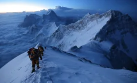
Max Elevation 5416m
Standard medium-hard
Season October to November, March to April
Start Besi Sahar
Finish Naya Pul or Beni
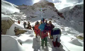
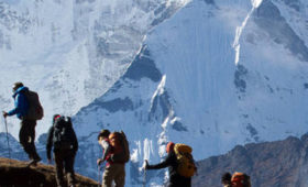
Summary Walk completely around the Annapurna massif. Trek through lowland villages to the remote Manang region, and down the Kali Garidaki. Cross a 5416m pass – probably the highest you’ll get without climbing a mountain.
It takes 16 days to trek about 300km around the entire Annapurna massif, visiting the Tibet-like country on the northern slopes of the Himalaya and the dramatic Kali Gandaki valley. Nepal opened Manang to trekkers in April 1977, although a few expeditions and scientific parties visited the region in the 1950s. The last part of this trek is the reverse of the popular trek to Jomsom, described earlier in this chapter.
PLANNING
Clothing & Equipment
Proper gear for porters must be a prime consideration if you are taking them over the 5416m Thorung La. Many lowland porters have suffered frostbite or snow blindness on this pass because trekkers have not provided the proper footwear, clothing and sunglasses. Porters from near-tropical villages like Besi Sahar have no idea what to expect on a snow-covered pass, or they hope that the pass crossing will be in warm weather, and join a trekking party clad only in flip-flops and cotton clothing. If you employ porters for a crossing of Thorung La, you incur both a moral and a legal obligation for their safety and well being.
Accommodation
There are frequent teashops and lodges all along the route. The lodges on this trek tend to be clustered in villages. ACAP has erected sings at the entrance to each village with a rough map showing the location of the hotels. between Best Sahar and Manang there are many places where you will walk for an hour or more without seeing a hotel or teashop. Once you reach Muktinath and the Kali Gandaki valley the facilities are much more frequent.
In most lodges the facilities are reasonably good, with private rooms as well as dormitory accommodation, although the lodges in the lower Marsyangdi valley are not as good as those in the Kali Gandaki or the Everest region. A strange, but common, feature of lodges in the Marsyangdi valley is a large bouquet of artificial flowers as a centre piece cm the dining table.
ACCESS
An express bus takes about five hours from Kathmandu to Dumre, the turn-off to Besi Sahar. The local buses are rough; you will be much happier if you book a seat on a tourist bus to Pokhara and get off at Dumre. Leaving the Kathmandu valley, the road descends on a wild series of steep switch-backs along the narrow Indian-built Trib-huvan Rajmarg. It then continues south through cultivated fields to Naubise, 26km from Kathmandu. Naubise is the beginning of the Prithvi Rajmarg, completed in 1971 with Chinese aid.
The Tribhuvan Rajmarg continues south from this point and winds its way towards the Indian border at Birganj. The Prithvi Rajmarg heads west along the Mahesh Khola to its confluence with the Trisuli. It then follows the Trisuli valley to Mugling (220m) at the confluence of the Trisuli and the Marsyangdi, 110km from Kathmandu. The large river thus formed flows south to become the Narayani, one of the major tributaries of the Ganges. Many rafting companies operate trips on these rivers, often emerging in the Terai and entering Royal Chitwan National Park.
Beyond Mugling, the road follows the Marsyangdi Khola, crossing the dam in front of the powerhouse of the huge Marsyangdi power project. A few kilometres beyond, at Anbu Khaireni, is the junction of the road to Gorkha. Dumre (440m) is 25km beyond Mugling. This village was settled in the 1970s by Newars from the nearby town of Bandipur after the completion of the road from Kathmandu to Pokhara. Most of Dumre consists of warehouses, shops and bhattis serving the porters who carry loads from the roadhead to remote villages. There are also a few lodges, including the Annapurna and Dhaulagiri, that cater to trekkers. Bring your earplugs if you’re planning to stay here, as noisy trucks and buses ply the road all night.
From Dumre it takes about an hour (longer by local bus) to cover the 42km to Besi Sahar. Crossing the Chudi Khola at Dumre, the road passes through terraced rice fields and small villages inhabited by Newars, Brahmans and Chhetris, to Bhansar at 530m. It then follows the west bank of the Marsyangdi upstream through a region dotted with gigantic banyan and pipal trees.
A short distance on, from the town of Chambas (500m) there are good views of the high Himalaya, especially Baudha (6674m) and Himalchuli (7893m). The road passes through the upper part of Turture at 530m; most of this large village is below the road. Across the river you can see Palangtar, the site of Gorkha’s defunct Palangtar airport.
The road stays on the west bank of the river through fairly level country. It fords a stream and climbs past some teahouses at Paundi Dik to Bhote Odar (550m). The road climbs over a ridge at 730m and descends to the Thakali bazaar of Phalensangu, which is below the road at 670m. After a few small ascents and descents and a lot of small stream crossings, you’ll reach Besi Sahar, on a plateau at 820m.
THE TREK
Day 1: Besi Sahar to Bahundanda
6-7 hours, 510m ascent Much of the first stretch of the trek is along the unfinished road that was designed to aid construction of a hydroelectric plant at Ngadi. The National Geographic map shows this as a road, but the power plant was never built and much of the road has been destroyed by landslides. Throughout the trek you will share the trail with mule caravans that transport supplies to remote villages. Mules travel from Besi Sahar to Manang village, although they only travel as far as Chame when there is snow high in the Manang valley.
At the north end of the Besi Sahar bazaar ignore the road and follow a rough rock staircase down to the Puwa Khola. Climb onto the roadbed and trek past Chanaute and the teashops of Belaute Bisaune to the Balung Khola. There may be a bamboo bridge here, or you may have to rock-hop across. There are several ups and downs as the trail makes its way through subtropical forests and the rice terraces of Sera, then past a Danish vocational school to Khudi. The Hotel Himalchuli View is on the outskirts of the village near a sign that announces you are entering the Annapurna Conservation Area. A long, sagging suspension bridge across the Khudi Khola leads to a mixture of tin and thatch-roofed houses, teahouses and shops at 830m. The old bridge is precarious, but fun. If you’re nervous, there is a new one about 10 minutes upstream next to a collection of government offices and the Blue Opera and Milan hotels.
Khudi is the first Gurung village on the trek. Most of the people in the wide river valley below Khudi are Brahmans and Chhetris, although there are a few Gurung villages in the side valleys and slopes above the river. Pass the small Kemix Guest House, the Khudi school and a forest nursery, then follow the road northward up the Marsyangdi valley. Himalchuli and Ngadi Chuli (also known as Manaslu II and formerly known as Peak 29), at 7879m, dominate the horizon.
Follow the road to Bhulbule (840m) and the Thorung La Guest House, which has been rebuilt after being destroyed by a landslide in August 1996. The trail leaves the road and descends to the Everest Garden Guest House, then crosses the Marsyangdi Khola on a long suspension bridge. Across the bridge is the Heaven Guest House and the ageing Hotel Arjun; there are other hotels, bhattis, a bakery and even a tailor in the centre of the village just above the bridge.
The first ACAP checkpost on the trek is next to the Hotel Manang. Here you will collect the first stamp on your entry permit. Beyond Bhulbule the trail travels up the east bank of the river, past a majestic waterfall 60m high that is surrounded by a tropical tree called a pandanus, or screw pine. Watch for langur monkeys playing in the treetops. The path wanders through small villages scattered among extensive rice terraces with continuing views of Manaslu (8156m) and Ngadi Chuli. There are a few trail junctions between Bhulbule and Lampata in each case take the trail to the left. The right-hand trails lead to villages on ridges above the Marsyangdi.
The mountain views disappear as you near Ngadi. This used to be only a winter settlement before trekkers proliferated, but now there are numerous hotels and restaurants. The Seasons Lodge, Sore Back Restaurant, Trekkers Lodge and Pisang Peak Lodge occupy picturesque positions in rice fields south of the village. Along the stone-paved main street of Ngadi are the Himalaya, Annapurna, Kamala, Mina and Marsyangdi lodges. There are also shops, porter hotels and a camp site near a defunct bridge.
Several trekkers have suggested that Ngadi is a more pleasant and cleaner place to stay than Bahundanda. Cross a stream beyond the tourist Ngadi to reach a Tibetan settlement and porter stop on the east side of a long suspension bridge that crosses the Ngadi Khola at 950m. There are excellent camp sites beside the river on both sides of the bridge. There is a plan to build a power plant on the Ngadi Khola, but there has been no progress for several years. The power poles along this part of the valley are not part of the new project; they bring electricity from the power station near Anbu Khaireni to this region. On the hills above the Ngadi Khola is Usta.
The trail moves gently upwards through scrub forests and across landslides for about 30 minutes, then climbs to some bhattis and cold-drink stalls opposite the rice terraces of Lampata. The trail winds around to the small Manaslu Lodge and a police check-post, then makes a short, steep climb to Bahundanda, an attractive village in the saddle of a long ridge at 1300m. There are a few shops and bhattis, a telephone office and the spotlessly clean Swiss Alpen Hotel around a pipal tree in the town square. The Tibetan Hotel & Vegetrain Restaurant is north of the square, the Mountain View and Super View hotels are on the ridge to the west. Bahundanda (‘hill of the Brahmans’) is the northernmost Brahman settlement in the Marsyangdi valley. There is an excellent camping ground at the school, nestled in a grove of bamboo to the east of town, with decent toilet facilities. In addition to a camping fee, you are expected to make a donation to the school.
Day 2:Bahundanda to Chamje
5-6 hours, 420m ascent, 260m descent Descend on a steep, slippery trail past amphitheatre-shaped rice terraces. The flocks of birds in the rice fields are slaty-headed parakeets. Contour across terraces to a teashop in a settlement aptly named ‘Under the Pipal Tree’. Drop to a log bridge across a stream at the foot of a waterfall and climb to the Eagle’s Nest Restaurant at Lili Bhir, where you can get directions to a small hot spring nearby. The trail traverses high above the river on an exposed trail past several small streams. It was along this stretch of trail, in August 2000, that Kanak Mani Dixit, editor of Himal magazine, fell while trekking alone and spent three days on a ledge before being rescued. Kanak later discovered he was not the first person to fall here and contributed the money to build a railing along the most dangerous part of the trail.
A climb over a ridge leads to the pleasant village of Kanigaon, at 1170m. The small Shangrila Guest House is at the south end of town and a flagstone-paved trail leads to the Peaceful Hotel at the north end. A short distance on is the large Crystal Guest House and numerous other hotels and small shops in Ghermu Phant opposite a huge waterfall.
If you’re looking for a place to stay, one of these hotels may be a better choice than the smaller, older hotels in Syange. The trail descends past the View Point Guest House to cross the Marsyangdi on a long, rattling suspension bridge at Syange (1080m). Shops, the New Thakuri Guest House and the Hotel Sonam line the stone street of Syange on the west bank of the river. One of the best camp sites on the trip is under the eastern end of the bridge below the Riverside Guest House. This is the last of the rolling Middle Hills. Beyond Syange the valley narrows and becomes a steep canyon.
A steep climb over a landslide leads to the New Asia Hotel at Shree Chaur, 30 minutes beyond Syange. There is a hot spring across the river and the hotel-keeper pipes the water across when the river is low.
Beyond Shree Chaur the trail climbs quite high on an exposed trail carved into nearly vertical cliffs, which are forested with rhododendron and pine and garnished with healthy crops of stinging nettles and marijuana. Because of the steep terrain, the villages in this region are small and infrequent. When Tilman visited Manang in 1950, this portion of the trail did not exist. Instead, the route followed a series of wooden galleries tied to the face of the rock cliffs alongside the river.
As you near Jagat, there is a steep 200m climb to a trail that has been blasted out of the rock face. The trail is a bit exposed, but it’s wide and safe. It’s a short descent past a small waterfall to Jagat (1330m), inhabited, as are most villages in this region, by people of Tibetan heritage. Jagat means ‘toll station’,this was once the site of a tax-collection post for the Tibetan salt trade of the Marsyangdi valley. The stone village has a medieval atmosphere and the shops and hotels are packed closely together. The big Tibetan Pemba Lodge, Everest Hotel and Sushima Lodge are near a bunch of bamboo shacks at the southern end of town; the Mont Blanc is at the northern end. There is a small hot spring 15 minutes below the village.
From Jagat, the trail descends and crosses a landslide to a small teashop near the Ghatta Khola. It’s then a long climb through forests past two bhattis and a waterfall to Chamje (1410m). Pass the Rainbow Hotel to reach the venerable Tibetan Hotel. Descend past a big overhanging rock to the school, the Potala Guest House and the three-storey Tibet Lhasa Guest House. Just across the suspension bridge on the east side of the river there is a camp site.
Day 3: Chamje to Bagarchhap
6-7 hours, 940m ascent Cross to the east bank of the Marsyangdi and follow the trail along the river embankment on rocks and exposed wire. These wire cages filled with rocks are called gabions. They are used extensively throughout Nepal to stabilise river banks and road cuttings. The trail passes under an overhanging rock, then climbs a rocky trail and a steep stone staircase to several teashops in Sattale (1480m).
Climb past fields, then through stands of bamboo and rhododendron to an exposed trail that traverses high above the steep river bank. The trail makes a short descent to Tal Besi, two hotels at 1590m, then makes a steep climb beside the Marsyangdi, which has become an underground waterfall beneath huge boulders. The trail crests a ridge marked by an ugly cement archway as the valley suddenly opens into a large plateau. In this dramatic setting, at the foot of a large waterfall, is Tal, at 1700m. There are many shops and lodges in Tal, arranged so they look like an old American pony-express outpost. The concrete Dragon Hotel is at the south end of town; the Annapurna Hotel and Lhasa Hotel are in the centre and the Tibetan Hotel is at the northern end. Don’t get your hopes up when you spot the sign on Jog Maya Gurung’s Manaslu Guest House offering ‘Fosters on tap’. There is another ACAP checkpost and visitor centre where your entrance ticket will again be checked and endorsed. The trek has now entered the Manang district the Buddhist influence is apparent from the small white chorten on a nearby hill.
The trail crosses the broad, flat valley that was once a lake (tal means ‘lake’), through fields of com, barley and potatoes. It crosses a small stream on a wooden bridge near the large Hotel Paradise, then makes its way along the riverbed to Shirental. A short distance on, it climbs to a 60m-long suspension bridge across the Marsyangdi at 1850m.
This portion of the trail was constructed in the 1980s to replace a trail on the eastern side of the river that was destroyed by landslides. Climb past several bhattis in Ningala. Follow a trail that has been blasted out of the side of the cliff past two waterfalls to the small Manaslu Lodge at Khorte. Descend past a bhatti in the forest to a long, high suspension bridge that leads to the east bank of the river and the Dorchester and New World hotels in Karte.
Follow the ACAP sign that leads you up a stone staircase and over a ridge behind Karte, then drop to a suspension bridge that goes back to the west side of the Marsyangdi. Just after the bridge is a tiny, dirty hot spring that flows from a fissure near the trail; you need a cup to collect the hot water.
The trail climbs from the bridge to a stone kani that marks the entrance to Dharapani, at 1960m. All the old villages from here to Kagbeni have entrance chortens at both ends of the village. The kanis get more elaborate and picturesque as the Tibetan influence becomes stronger in each successive village.
There are three parts to this village. In lower Dharapani you will find the Hotel Manaslu, Annapurna Guest House, Mukti- I nath Lodge, the Ganga Jamuna Hotels the telephone office, shops, a police checkpost and the first of Manang’s many ‘German’ bakeries. The Peak 29 Hotel, Trekkers Hotel and New Tibet Guest House are beyond the entrance chorten to the north of the town. About 10 minutes further on are the Tibetan Hotel, the Kangaroo Guest House and the funkier Dharapani Hotel & Lodge at 1960m. A small hydroelectric plant provides 24-hour electricity.
There’s a long suspension bridge across the Marsyangdi that leads to Thonje, an important village at the junction of the Marsyangdi and the Dudh Khola. It’s not necessary to go to Thonje en route to Manang. The police checkpost in Thonje controls the route up the valley that leads to Larky a La. If you have trekked around Manaslu, you will emerge here and can either continue to trek around Annapurna or trek south to Besi Sahar and Dumre. The building with the huge tin roof in Thonje is the regional high school.
Beyond Dharapani, the trail passes a school and climbs over a spur. A stone staircase leads uphill to the west. Take the lower, right-hand trail or you’ll end up in the remote village of Kotre. Tlie trail is generally level for the 30-minute walk to 1 Bagarchhap through a forest of blue pine, spruce, hemlock, maple and oak. The jay like bird that you see is the nutcracker; it eats the seeds from the blue pine cones.
Bagarchhap, at 2160m, is the first village on the trek with typical Tibetan architecture: closely spaced stone houses, with flat roofs piled high with firewood. During the same storm that produced avalanches in eastern Nepal in November 1995, a landslide roared through Bagarchhap and destroyed much of the village, including two lodges. At the entrance to the town is a memorial to those killed. The village has been rebuilt, but there is still evidence of the destruction. The Marsyangdi Hotel and Pisang Guest House were rebuilt in Bagarchhap, but many hoteliers rebuilt their lodges in Danaque, 30 minutes up the valley. The well-maintained, whitewashed Diki gompa in Bagarchhap is worth a visit; it contains many Tibetan Buddhist paintings and statues. At the west end of the village is the large, new Buddha Lodge.
The trek has now entered the east-west Manang valley and travels west up the valley with high Himalayan peaks to the south. There are occasional glimpses of Lamjung Himal (6986m) and Annapurna II (7937m) through the trees. To the east, some of the peaks of Manaslu Himal provide a dramatic backdrop at the foot of the tree-filled valley.
Day 4: Bagarchhap to Chame
5-6 hours, 550m ascent Much of the Manang valley is virgin forest of pine and fir, but construction of new houses and hotels and the constant requirement for firewood are causing people to cut down many of these fine trees. The trail stays on the south bank of the river, climbing through forests to Danaque, also called Syal Khola (‘the river of jackals’), at 2210m, where many people from Bagarchhap have resettled. It’s a spread-out village with many large hotels. You’ll first reach the Annapurna, Snowland and Hotel Tibetan, and a short distance later the Himalayan and Thakuri hotels near a new mani wall and huge prayer wheel. Just beyond an apple orchard (apples and peaches an available everywhere in the region during 1 the autumn) are the Potala Guest House and the larger Trekkers Hotel.
Beyond Danaque the route crosses a stream on a wooden bridge, then reaches a trail junction. The usual route to Manang is the right fork. The left-hand trail leads south to Temang and the Hotel Royal Garden at 2600m, then joins a path from Temang to Kotho that offers an alternative high route to the main trail. It is sometimes necessary to travel via Temang if there are severe landslides on the lower trail. Frequent landslides make the next stretch of trail a difficult walk; ask in Danaque for advice about which route to take.
Long ago, before the trail up the Mars-yangdi was built, the route to Manang went via Temang, climbing over Namun Bhan-jyang (5505m) en route to Ghanpokhara in the south. Few people, other than herders use it now. Namun Bhanjyang is a difficult pass because there is often snow, and there is no food or shelter for four days.
A broad, level stretch of trail leads through forests to a cement bridge near a spectacular waterfall. Traverse a rock ledge, climb over a ridge on a steep, rocky trail and descend to the tiny settlement of Temang Besi. Look for the beehives under the eaves of the houses here. The route crosses several landslides (you may have to climb over the top of some) as it works its way uphill through a forest of walnut trees to the Tatopani Lodge at the top of Lattemarang-Lower in the village, at 2440m, are the small, rustic Annapurna and Mountain View lodges. There is a tiny hot spring across the river, but it is hard to get to.
The track makes several ups and down over forested ridges and landslides, the crosses a large stream before climbing tp teashop next to an apple orchard. A crossing another landslide the track reach the modest Hotel Marsyangdi in the forest clearing of Thanchok Besi. Trek across other ridge to the entrance chorten (2640m), also known as Kyupar.